For all of you who have been emailing that all this talk of such an early nor'easter is "nuts" because "..it is way to early and not even winter yet", I remind you that a year ago, a scant 3 days after Super Storm Sandy (a hybrid winter/post-tropical storm in itself), a nor'easter named Winter Storm Athena rolled over us with a gift of cold air and some 3 inches of snow and ice.
Additionally, after Sandy, I tend not to take any possible significant weather event lightly and nor'easters, as you are all acutely aware, tend to be messy events with winds and coastal flooding which can cause problems.
Whether or not there will be a significant weather event along the East Coast during the middle of next week depends on where the leading edge of the arctic air stops.
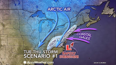
SCENARIO #1
If the leading edge of the arctic air pauses right along the coast, it will set up a south to north storm track with all of the potential impacts of a major nor'easter for our area.
If a storm does develop and track south to north, right now it appears we would be impacted mid-week, Wednesday-Thursday, with a wind, rain/snow and minor coastal flooding event.
If a storm does develop and track south to north, right now it appears we would be impacted mid-week, Wednesday-Thursday, with a wind, rain/snow and minor coastal flooding event.
SCENARIO #2
If the arctic air sweeps forcefully off the coast, it will erase any chance of a major coastal snowstorm.
Keep in mind that Atlantic Ocean waters, which are still relatively warm this time of the year, tend to delay the arrival of cold air and shifts the track of coastal storms farther inland which favors snow well inland and rain at the coast.
So for there to be a major snowstorm along the coast, the setup would have to be perfect to compensate for the warm Atlantic Ocean.
I tend to favor scenario #2 above with a fast moving low pressure system moving quickly east out to sea before really intensifying with no impact to our area. Nevertheless, the bottom line is that all we know right now is that we will get a blast of Arctic air next week and after that, all of this is still just informed conjecture.
We will update you as new information becomes available.


No comments:
Post a Comment